Lakes and rivers
In Sardinia there are many lakes although only one is natural; the lake Baratz. This lake of modest dimension is situated in Nurra d'Alghero-Sassari near the coast and at the foot of a hill. The scarcity of lakes is with regard to 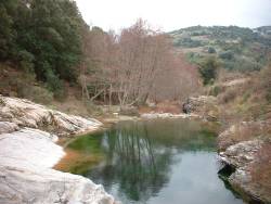 geological history because the island was not affected by the glacial era or more recent tectonic events.
The major lakes found in Sardinia are artificial, in other words introduced by man to achieve the following goals; as a water reserve, to contain floods, to irrigate and to produce electric energy. The numerous coastal and internal lakes characterise the island.
The major coastal lakes are situated for the large part in Ogliastra (Cabras, S. Giusta and Marceddi) and in the zone of Cagliari (S. Gilla and Molentargius) and other minor lakes throughout the plains of the island. The internal lakes present mostly in the area of Cagliari contain salt-water, formed by the filter of water from high ground stepped in semi-arid climate. The temporary inland water reserves are not usually very deep and contain stagnant water.
*Rivers*
On the island of Sardinia there are four major rivers; Coghinas, Flumendosa, Tirso and Flumini Mannu, but there are also other minor rivers such as the Temo (the only navigable river), the Cedrino and the Rio Posada 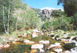 with many other smaller rivulets and streams that spread over a notable area.
The most important rivers of Sardinia flow to the coasts of the island after having covered a distance equal to 9963 square kilometres. The Coghinas, that takes its name from the thermal springs near its mouth, has its source in Gallura, is fed by the waters of Rio Mannu at Berchidda and Rio Mannu at Ozieri, crosses the Anglona and flows into the Gulf of Asinara.
This is the third longest river in Sardinia (123km) and the second largest for its water capacity. In the occidental part of the island flow the Temo (Bosa), the Tirso (Gulf of Oristano), the Rio Mannu (Pabillonis) and the Rio Palmas. The Tirso, with its origin in Thyrsus, is the longest river in Sardinia with a distance of 159km. It springs from the granite high plains of Buddusò and irrigates the central-occidental area, finally flowing into the Gulf of Oristano.
The Flumendosa is the most important river on the island not only for its length and capacity but also for its water quality and the way in which it is used. The Flumendosa has its source in the mountains of Gennargentu, occupies the entire south-oriental part of the island and, after crossing Barbagia, Ogliastra, Sarcidano and Serrabus, flows through Muravera and Villaputzu.
The predominantly impermeable nature of the terrain, the sudden floods, the narrow river beds and the accentuated sloping of its profile have, in the past, provoked numerous floods in the coastal lands. For its hydro-geological characteristics and the impermeability of the lands, the Flumendosa channels great masses of solid material, debris and other materials into the sea accumulating at the river mouth creating a growth of littoral terrain and marine talus.


